San Antonio River Brochure
Introduction
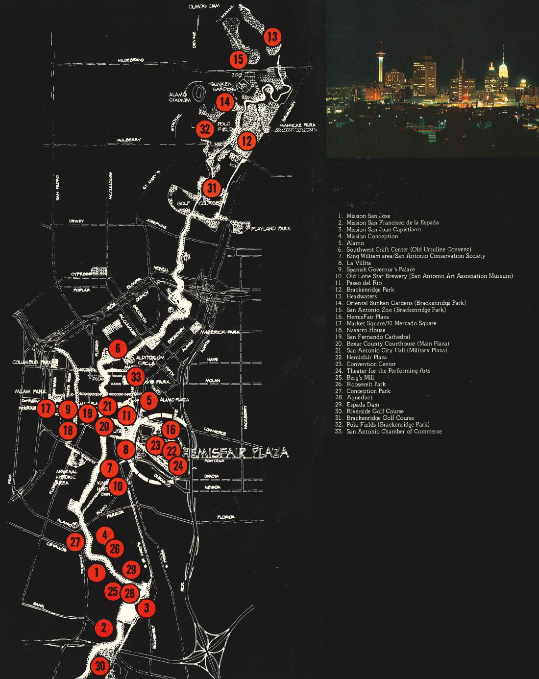
A Special Place traces the history of the interaction between the natural and the man-made elements in the San Antonio River setting. The production explores the story of the river in the life of the city and the lives of its citizens. The San Antonio River laces through the center of San Antonio, TX, providing a green corridor through the city. A priceless environmental asset, this spring-fed stream comes to life in the northern part of the city, winds its way through downtown, proceeds south by the old Spanish missions, then leaves the city to continue its journey to the Gulf of Mexico. The story of the river is intertwined with that of the city whose name it shares. In fact, the river is the reason for the city's existence. By examining this history and functioning of this river and the city built around it, it is possible to gain insights into some of the issues that confront American cities today.
Environmental Preservation
When European explorers made their way to South Texas in 1691, they discovered a settlement of peaceful Indians living beside a clear stream fed by artesian springs. Father Massanet, a priest who accompanied them, celebrated Mass by the river and named it for Saint Anthony of Padua.
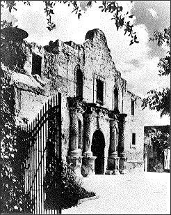
Much of the history of the city, the region, and the State of Texas is identified with this little stream. From the acequias (a Spanish term for the irrigation canals built by the founding missionaries) to today's modern skyscrapers, many important buildings were built beside the river. These include the famous mission known as the Alamo as well as a number of impressive structures such as the Missions San Jose, Concepcion, Espada, San Juan; the Spanish Governor's Palace; the old Ursuline Academy, and many more buildings from the eighteenth and nineteenth centuries.
Early in the twentieth century, the little river fell into disfavor because of disastrous flooding in 1913 and 1921. The city government made plans to convert the river into a storm sewer system by straightening the river and diverting its water through a concrete tunnel. Some citizens felt that the lovely little stream was too valuable an asset to lose, so they began a movement to save the river. From these efforts came the San Antonio Conservation Society. The river was saved, and organized environmental preservation efforts became a part of the life of the community.
Today the city of San Antonio has a unique heritage of buildings that have found a new use and purpose. The beautiful King William section of the city, on the river just south of downtown, is undergoing a renaissance. The San Antonio Museum Association is converting an old riverside brewing complex into an art museum. The citizens of San Antonio have demonstrated that environmental preservation can be an asset to a city. Preservation efforts have both private and public support. In fact, the City of San Antonio has a full-time Historic Preservation Officer who helps to insure that the environmental heritage of the city will be considered and protected.
(click image for a larger version)
Citizen Participation
Today, the San Antonio River exists as a city asset because ordinary citizens cared for the river. In the early 1920s, citizens saved the river from destruction. Later in that decade a young architect had an idea for downtown development along the river. Community leaders supported this idea, and during the 1930's the Works Progress Administration (WPA) and the National Youth Administration (NYA) sponsored projects to build some of these improvements. In the early 1960's a committee from the Chamber of Commerce, together with a committee from the American Institute of Architects, worked to further improve the river and to revive its use as an important part of downtown.
This citizen participation continues in many forms. Organizations such as the Paseo del Rio Association, the Riverwalk Commission, and the River Corridor Committee actively pursue protection and development of the river and its surroundings. In addition there are neighborhood groups I such as the King William Association and the River Road Association. These groups work separately and together to insure the safeguarding of the river as well as plans for its future enhancement and use.
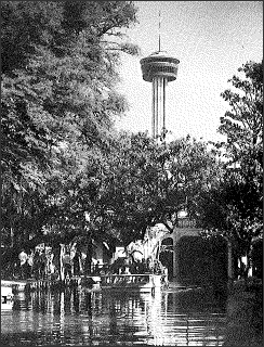
The river is important to the citizens because they use it often and well. In the downtown it provides a staging ground for an extraordinary life of public festivities and celebrations. During a single year, over eleven special events will be held along the river. Some examples are the springtime week of Fiesta, the Fiesta Noche del Rio which occurs in summer, fall's Volkfest and winter's Fiesta de Las Luminarias and Las Posadas. In addition to many city-wide events, the river provides a place for individuals and groups to stage their own special events. It is possible for a family to celebrate a birthday by planning a dinner floating on a river barge, complete with mariachi serenades. And organizations throughout the city can plan activities on the river, such as the school bands and choirs who ride the boats at Christmas, playing and singing for the passersby and customers in the riverside cafes.
The numerous parks, golf courses, hike and bike trails, horseback paths, and playing fields that occupy the riverbanks provide an opportunity for each and every citizen to have easy year-round access to recreation facilities. Many cultural institutions have been built beside the river, such as art museums, an arts and crafts schooL and a performing arts complex. In San Antonio, the public life of the community is inextricably linked with the river setting.
 (click image for a larger version)
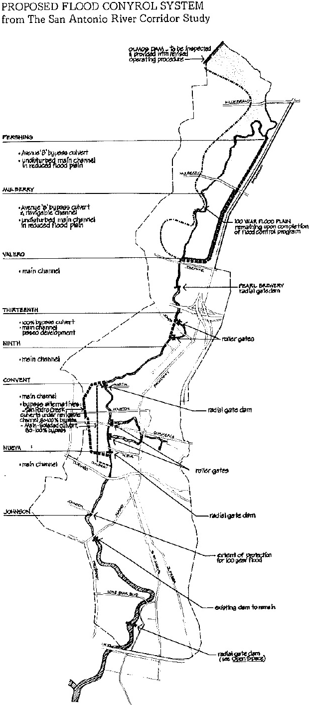
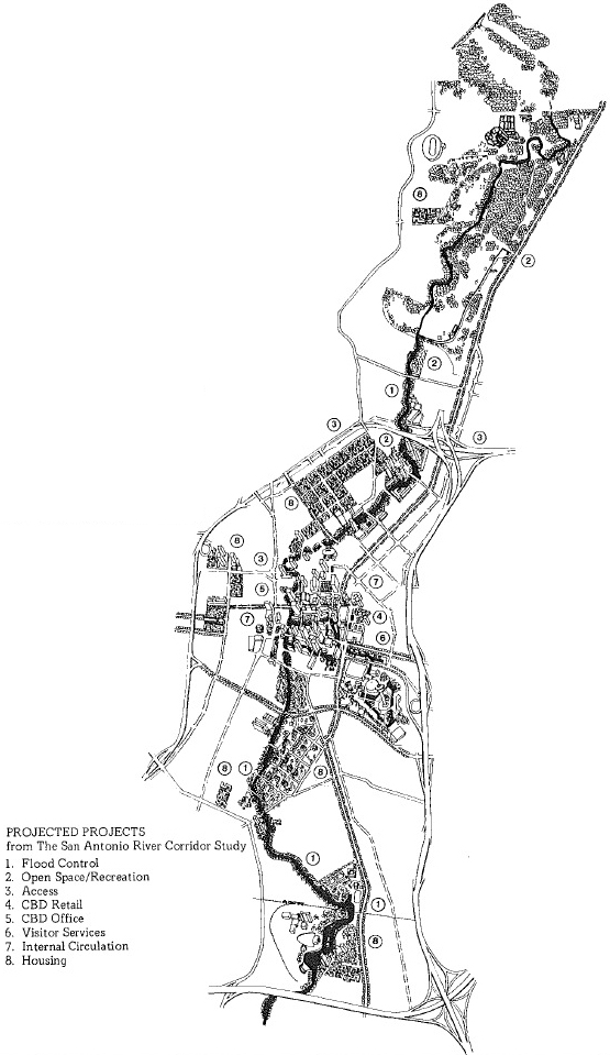
Flood Control
The problem of flood control is one that has not been totally solved. Although certain protective steps have been taken, there is still much work to be done. The flood control efforts that lie ahead will be costly because the river runs through the heart of the city. Flood control measures will have to be devised that will protect the community without destroying either the buildings or the natural beauty of the river corridor. Design of this flood control presents special problems. Engineers must preserve the natural and built environments while still protecting the city. This will undoubtedly be a lengthy, expensive, and controversial undertaking. The City of San Antonio and its citizens are confronting these problems in many ways. The River Corridor Committee, with a membership composed of representatives of 36 community organizations and 6 public agencies, has a special Task Force on flood control. The San Antonio River Authority and the United States Corps of Engineers are working together to accomplish flood control of the San Antonio River so that the river will be both safe and beautiful.
Urban Design
As architecture is concerned with the design of a single building, urban design is concerned with the design of the city. Architecture focuses on the relationship among elements in one building; urban design focuses on the relationship among all the elements in the city environment both built and natural.
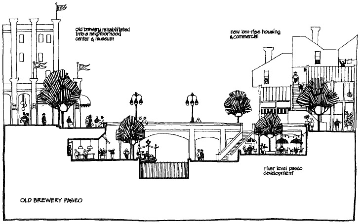
The San Antonio River has provided an exciting urban design opportunity. In the downtown River Bend area, efforts have been made to pull the various elements-buildings, street furnishings, planting, bridges, lighting, etc.into a pleasing and interrelated whole. There is still much work to be done in order to extend this design effort to other parts of the river. One existing urban design challenge is to better integrate the below-ground-level river environment with the street-level city environment. If the street-level environment could be connected with the river and if it could achieve the same design standard as the river-level environment San Antonio's environmental quality would be greatly enhanced.

(click image for a larger version)
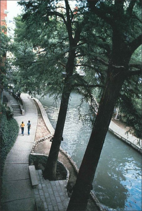
Pedestrian System
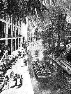
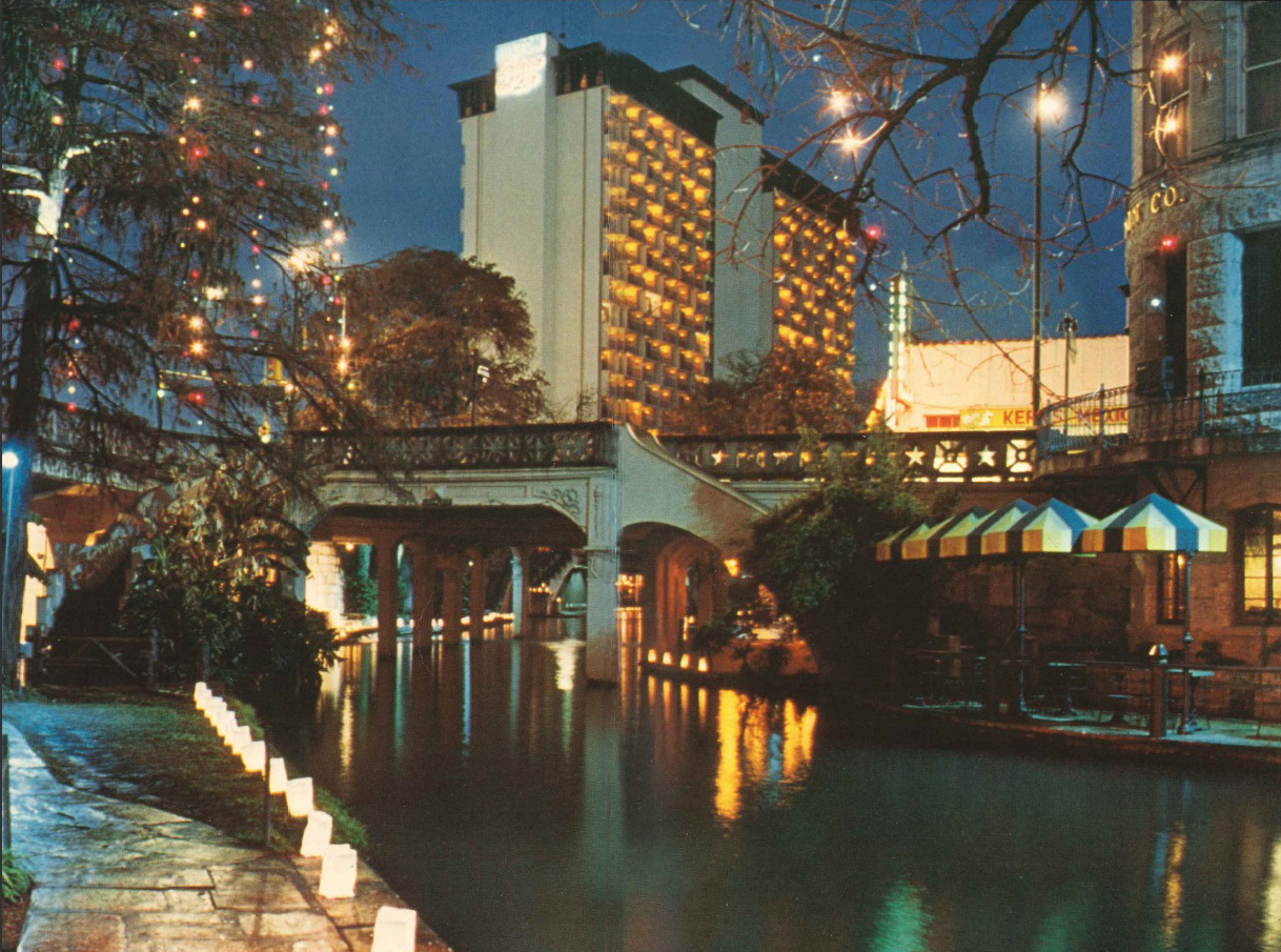
One of the significant advantages that the river affords for the city is that of providing a safe and attractive pedestrian system for the downtown. n' There are 3.51 miles of pedestrian walks lining the banks of the river in the heart of the city. It is possible to traverse the entire downtown area at river level, never confronting the street with its noise, congestion, and disheartening visual confusion. The pedestrian can step from the street to the depressed river level and be in a world of trees, birds, plants, flowers, music, and charm.
 (click image for a larger version)
Because of the depression of the river below ground level, a microclimate is created that remains a bit warmer in winter and cooler in summer than the streets above. This allows the plant-life along the river to flourish. The City Parks Department performs an admirable service of maintenance so that the pedestrian paths are always well-tended and attractive. In addition, well-designed walks and benches invite the pedestrian to stroll and enjoy the city at his or her leisure.
The security of the riverwalks is well-established. Good lighting illuminates the area without being obtrusive and ugly. Park Rangers patrol by boat and on foot, providing a friendly security and information presence. Another significant security factor is the fact that people use the river. The presence of active users does much to discourage crime and violence. Because of the riverwalks, San Antonio can offer its citizens a safe, attractive, active pedestrian environment.
River Facts
The San Antonio River is:
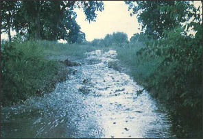
- small in scale
- a first-order stream* which has its source in precipitation and in springs
- flows southeast from the city of San Antonio for approximately 238 miles to empty into the Guadalupe River
- flows north to south through the center of the city
- subject to erratic flow due to variable and erratic nature of precipitation in the region
- depressed 15 to 20 feet below ground level throughout the city
- used for waste disposal.
* According to the river classification system devised by hydrologist Robert E. Horton.
Events Along The San Antonio River
1535
 Crossed by Alvar Nunez Cabeza de Vaca in his journey across Texas
1631
Father Damian Massanet celebrated Mass at the Indian village of Yanaguana and named the place San Antonio
1718
Father Antonio de San Buenaventura Olivares founded Mission San Antonio de Valero
1722
Mission San Jose y San Miguel de Aguayo founded
1730
Missions San Juan Capistrano, Purisima Concepcion, and San Francisco de la Espada moved from East Texas to river; first acequia built
1731
Villa San Fernando de Bexar established for Canary Island settlers
1736
First bridge across the river
1776
A new acequia known as the Upper Labor Ditch was begun
1809
Southeast section of village called La Villita developed
1830
First city regulations for the use of river, creek, and ditch waters
1836
Alamo siege bought time for Sam Houston; defeat of Santa Ana; birth of Texas Republic
1837
San Antonio chartered by Republic of Texas
1845
Spanish is the first language in San Antonio as Texas entered Union
1852
St. Mary's College founded on river behind church
1853
Ursuline Sisters started school for girls in abandoned house
1859
Guenther built mill on river (now Pioneer Flour)
1875
First mansions built on King William Street; San Antonio was center of the country's wool industry
1876
Fort Sam Houston opened
1877
Beef and hides were major industries as barbed wire was introduced on Main Plaza; railroad came to San Antonio; water works begun; Guenther family began upper mill at Arsenal Street and river; river rate of flow measured at 16,149 cfm or 269 cfs
1879
First telephone in San Antonio connected Water Works office with pump house on river's headwaters
1888
First international fair held on new fairgrounds 3 miles south of city next to Riverside Park
1890
San Antonio population hit 36,673; streetcars ran from town to Riverside Park
1898
While camped along the river, Teddy Roosevelt recruited and trained Rough Riders to fight in the Spanish-American War
1910
Revolution in Mexico brought thousands of refugees and immigrants to San Antonio
1921
Fifty lives lost and millions of dollars damage done by flood
 (click image for a larger version)
1929
San Antonio Light published river improvement plan of R. H. H. Hugman
1935
Hotelman Jack White began campaign for river improvement
1938
Works Progress Administration (WPA) agreed to do channel improvement
1940
First river carnival and night river parade
1962
Riverwalk Commission established; Paseo del Rio master plan begun
1964
National Park Service studied Mission area
1968
Hemisfair opened; river extension dedicated
1972
Department of Housing and Urban Development granted $405,000 for River Corridor Feasibility Study; Corps of Engineers completed river improvements to Johnson Street; Corps received American Institute of Architects Award for improvements
(click image for a larger version)
Credits
DIRECTOR
Warren Skaaren
PHOTOS
Daughters of the Republic of Texas Library
Texas Highway Department
San Antonio Convention and Visitors Bureau
MAPS
San Antonio River Corridor Study, City of San Antonio
PROJECT CITYSCAPE ADVISORY BOARD
Vicki L. Beal - San Antonio, Texas
Peter Chermayeff - Boston, Massachusetts
Andrew Euston - Washington, D.C.
John L. Kriken - San Francisco, California
Weiming Lu - Dallas, Texas
Nancy Brown Negley - San Antonio, Texas
Patsy Swank - Dallas, Texas
PRODUCED BY
Project CITYSCAPE
Sherry Kafka Wagner, Project Director
1977
Southwest Educational Development Laboratory
4700 Mueller Blvd.
Austin, TX 78723
James H. Perry, Executive Director
This project, produced by Southwest Educational Development Laboratory, was supported by funds from the Office of Environmental Education, Department of Health, Education, and Welfare, Grant Number G007602033. The content of this booklet does not necessarily reflect the position or policy of the Office of Environmental Education, and no official endorsement should be inferred.
BROCHURE DESIGN
Gene Vitale